
DATA 037
Physical Disorder of Streets in 264 Chinese Cities (2015)
Beijing City Lab Data
Type & Source This dataset and accompanying Python code replicate the analysis described in the paper “Measuring physical disorder in urban street spaces: A large-scale analysis using street view images and deep learning.” It involves a nationwide assessment of physical disorder using Street View imagery and a deep learning pipeline based on MobileNetV3. Contents Python Code (MobileNetV3): A PyTorch implementation of MobileNetV3 trained to detect 15 disorder-related visual features (e.g. abandoned buildings, graffiti). Pre-trained models and usage instructions are included ( README.md ). Training Samples: Labeled...
Media / 图片视频
Source Images / 原始图片
Text / 正文
Type & Source
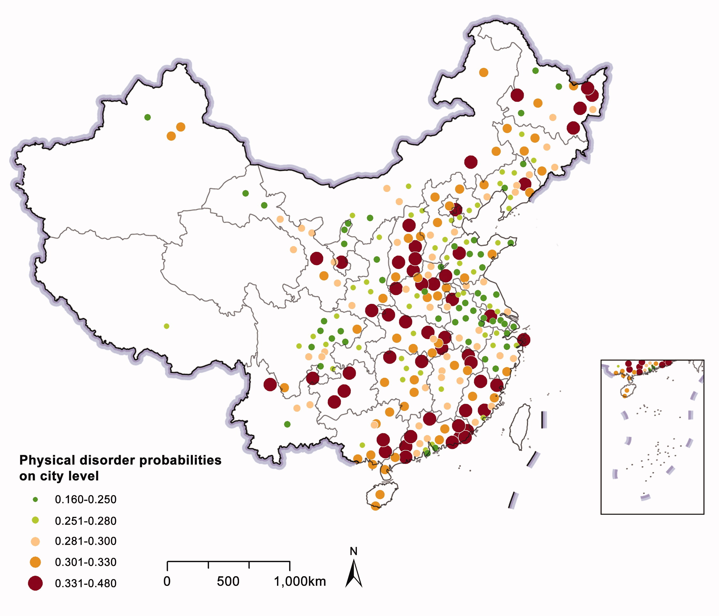
This dataset and accompanying Python code replicate the analysis described in the paper “Measuring physical disorder in urban street spaces: A large-scale analysis using street view images and deep learning.” It involves a nationwide assessment of physical disorder using Street View imagery and a deep learning pipeline based on MobileNetV3.
Contents
- Python Code (MobileNetV3):
- A PyTorch implementation of MobileNetV3 trained to detect 15 disorder-related visual features (e.g. abandoned buildings, graffiti). Pre-trained models and usage instructions are included (
README.md). - Training Samples:
- Labeled image samples used to train the model, also suitable for retraining or transfer learning.
- Virtual Audit Tool:
- A lightweight Python GUI tool for image labeling. Supports sorting images into folders by label.
- Physical Disorder Results (Shapefiles):
- china_cities.shp
- Attributes:
- ID: unique city ID
- name, nameEng: city names in Chinese and English
- mode: spatial pattern of disorder — (a) scattered, (b) diffused, (c) linear
- pdvalue: composite physical disorder score
- Disorder values per factor (e.g. AB = abandoned buildings)
- china_streets.shp
- Attributes:
- streets, name, nameEng
- pdvalue: street-level disorder score
- Factor-specific values (e.g. TR = trash)
- china_svipoints.shp
- Attributes:
- point_id, street_id
- pdvalue: point-level disorder score
- Factor-specific values for ~1.2 million sample points
Access & Document
Physical disorder of streets in 264 Chinese cities (2015) - Mendeley Data
Updated Protocol, Code & Model
The original nationwide dataset remains available as Mendeley Data version 1. A later protocol release provides updated assessment code and YOLOv8 models: Mendeley Data, version 2 · DOI: 10.17632/d3d4h5bvss.2.
Citation
Chen, J., Chen, L., Li, Y., Zhang, W., & Long, Y. (2022). Measuring physical disorder in urban street spaces: A large-scale analysis using street view images and deep learning. Annals of the American Association of Geographers. https://doi.org/10.1080/24694452.2022.2114417.
Downloads / 下载
Files / 附件下载
File
No downloadable file listed / 暂无可下载附件