
DATA 014
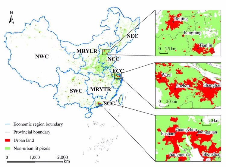
DMSP/OLS Interpreted Urban Areas of China 2008
Beijing City Lab Data
Type & Source Urban‑land raster derived from Defense Meteorological Satellite Program’s Operational Linescan System nighttime stable‑light imagery; produced by Dr He Chun‑yang (Beijing Normal University) for the BCL group. Format ESRI GRID. Citation Yang, Y., He, C., Zhang, Q., Han, L., & Du, S. (2013). Timely and accurate national-scale mapping of urban land in China using Defense Meteorological Satellite Program’s Operational Linescan System nighttime stable light data. Journal of Applied Remote Sensing , 7(1), 073535. https://doi.org/10.1117/1.JRS.7.073535 .
Media / 图片视频
Source Images / 原始图片
Text / 正文
Type & Source
Urban‑land raster derived from Defense Meteorological Satellite Program’s Operational Linescan System nighttime stable‑light imagery; produced by Dr He Chun‑yang (Beijing Normal University) for the BCL group.
Format
ESRI GRID.
Citation
Yang, Y., He, C., Zhang, Q., Han, L., & Du, S. (2013). Timely and accurate national-scale mapping of urban land in China using Defense Meteorological Satellite Program’s Operational Linescan System nighttime stable light data. Journal of Applied Remote Sensing, 7(1), 073535. https://doi.org/10.1117/1.JRS.7.073535.
Downloads / 下载