
DATA 053
FROM-GLC Plus 3.0: Multimodal Land Change Mapping with SAM and Dense Surface Observations
Beijing City Lab Data
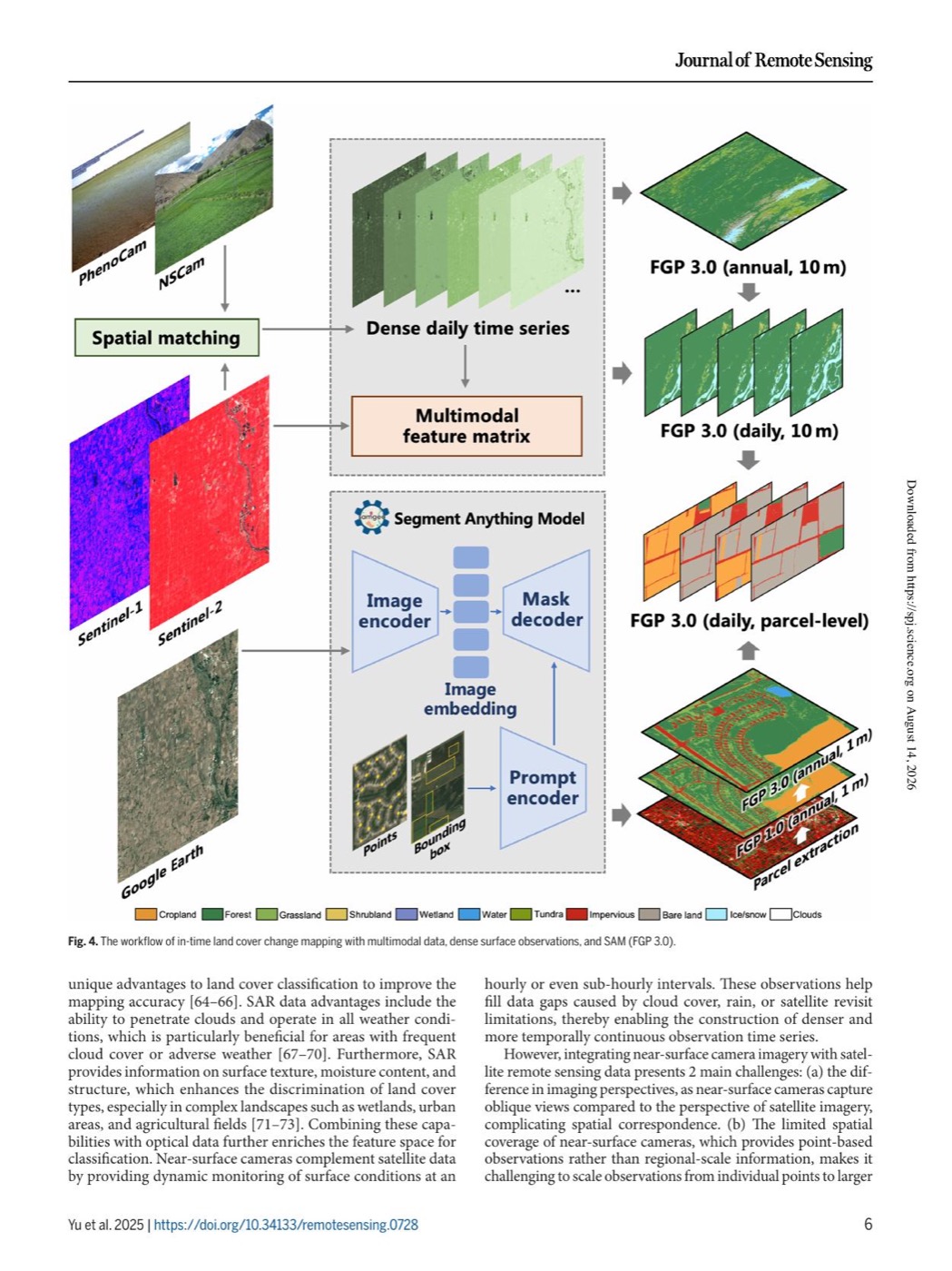
Type & Source This dataset accompanies the Journal of Remote Sensing article FROM-GLC Plus 3.0: Multimodal Land Change Mapping with SAM and Dense Surface Observations . It supports multimodal land-cover change mapping by combining near-surface camera observations, Sentinel-1/2 satellite imagery, dense daily time series and the Segment Anything Model (SAM). The release covers annual and daily 10-m land-cover products, daily parcel-level outputs and the associated mapping workflow across eight global 5° × 5° study grids. Contents & Method Near-surface camera observations aligned to satellite imagery through spatial...
Media / 图片视频
Source Images / 原始图片
Text / 正文
Type & Source
This dataset accompanies the Journal of Remote Sensing article FROM-GLC Plus 3.0: Multimodal Land Change Mapping with SAM and Dense Surface Observations. It supports multimodal land-cover change mapping by combining near-surface camera observations, Sentinel-1/2 satellite imagery, dense daily time series and the Segment Anything Model (SAM). The release covers annual and daily 10-m land-cover products, daily parcel-level outputs and the associated mapping workflow across eight global 5° × 5° study grids.
Contents & Method
- Near-surface camera observations aligned to satellite imagery through spatial matching.
- Dense daily Sentinel-2 time series and multimodal feature matrices, complemented by Sentinel-1 and high-resolution imagery.
- Annual, daily and parcel-level FROM-GLC Plus 3.0 land-cover mapping outputs, including cropland, forest, grassland, shrubland, wetland, water, tundra, impervious, bare land and ice/snow classes.
- SAM-based prompt segmentation for parcel-level land-dynamics monitoring.
Citation
Yu, L., Du, Z., Li, X., Gu, J., Li, X., Zhong, L., Duojiweise, Wu, H., Zhao, Q., Ma, X., Zheng, J., Yang, Y., Song, W., Wang, P., Zhao, Z., Liao, L., Long, Y., Zhang, Y., Peng, J., Shen, M., Li, T., Sun, Z., Zhao, Y., Wu, C., Lin, G., Luo, Y., & Peng, D. (2025). FROM-GLC Plus 3.0: Multimodal Land Change Mapping with SAM and Dense Surface Observations. Journal of Remote Sensing, 5, 0728. https://doi.org/10.34133/remotesensing.0728
Dataset Access & Citation
Yu, L., Du, Z., Li, X., et al. (2025). FROM-GLC Plus 3.0: Multi-modal Land Change Mapping with SAM and Dense Surface Observations [Data set]. Figshare. https://doi.org/10.6084/m9.figshare.29117393. The dataset record is available from Figshare under a CC BY 4.0 licence.
Related BCL publication
Downloads / 下载
Files / 附件下载
File
No downloadable file listed / 暂无可下载附件